

-
Recent Posts
- Dr. Hongbo Su received the Certification in Effective Teaching from ACUE
- Dr. Hongbo Su completed an ACUE course training on “Promoting Active Learning Online”
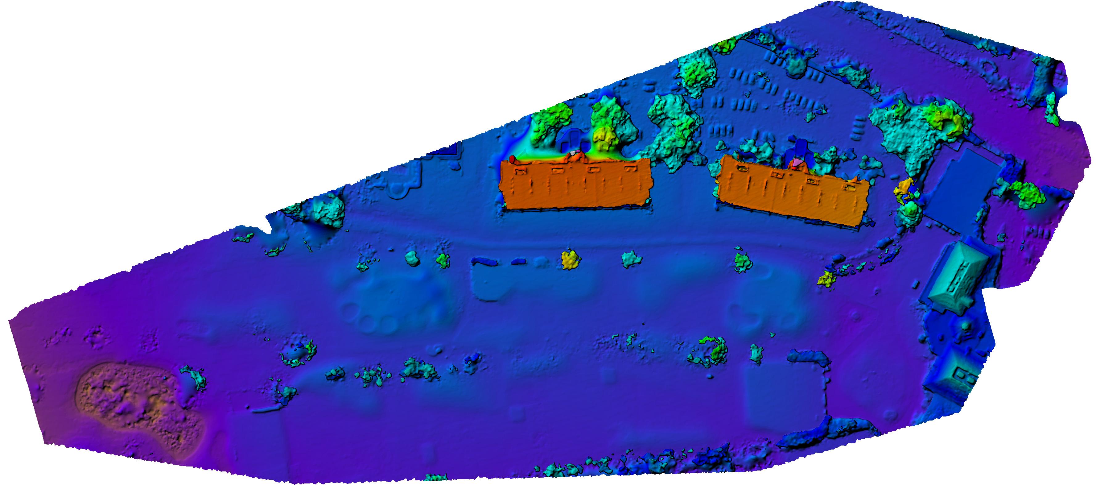
- New Research Boosts Flood Risk Planning with Smarter Mapping Tools
- Dr. Hongbo Su completed an ACUE course training on “Inspiring Inquiry and Preparing Lifelong Learning”
- Dr. Hongbo Su completed a training on “Creating an Inclusive and Supportive Online Learning Environment”
Archives
- April 2026
- March 2026
- August 2023
- July 2023
- April 2023
- December 2022
- October 2022
- February 2022
- November 2021
- September 2021
- August 2021
- July 2021
- January 2021
- March 2020
- September 2019
- August 2019
- July 2019
- March 2019
- January 2019
- September 2018
- July 2018
- February 2018
- August 2017
- March 2016
- February 2016
- October 2015
- September 2015
- August 2015
- August 2014
Categories
Meta
Category Archives: News
Decision support system for urban major hazard installations management based on 3DGIS
A journal article on the application of 3DGIS was recently published by Wenjiang Chen, Hongbo Su, Yong Yan and Zhaoji Hu on
Physics and Chemistry of the Earth, Parts A/B/C
Highlights of the Article:
- • A 3D reconstruction method of
Posted in News, Publication, Research
Comments Off on Decision support system for urban major hazard installations management based on 3DGIS
Mapping Historical Changes in Florida’s Coastline from 1875 to 2000
Florida’s beaches are highly dynamic coastal features. They are vulnerable to accretion and erosion over time due to human interaction and climate change stressors such as storm activity. This research used a well-documented record of historical land surveys and literature, …
Jason Blankenship was awarded the Francis H. Moffitt Memorial Scholarship from ASPRS
FAU Geomatics graduate student, Jason Blankenship, won the Francis H. Moffitt Memorial Scholarship from the American Society for Photogrammetry and Remote Sensing (ASPRS) during the ASPRS 2018 meeting in Denver Colorado on Feb. 6, 2018. Jason received $7000 and one-year …
Piesat 4.1 Software
FAU Geomatics and Beijing PIESAT Information Technology Co., Ltd started a partnership to develop applications based on the software package Pietsat 4.1.
The software can be downloaded from this link.
![]() …
…
Posted in News
Comments Off on Piesat 4.1 Software
We developed a new approach to count cars on the road automatically using traffic cameras
Posted in News, Publication, Research
Comments Off on We developed a new approach to count cars on the road automatically using traffic cameras
Celebrating National Surveyors Week at FAU
Click here 2016 Surveyors Week Celebration for a detail announcement:
Organized by the Florida Surveying and Mapping Society FAU, Broward, Indian River, Miami and Palm Beach Chapters
Thursday, March 24, 2016
5:30 – 9:00 p.m.
FAU Engineering East Atrium
777 …
Posted in News
Comments Off on Celebrating National Surveyors Week at FAU
Presentation & Question/Answer Session with Florida Board of Professional Engineers (on Feb. 24) at FAU
Plan to take your FE exam? This is a good opportunity to find out more insider information on how to prepare your FE exam.
Location: Engineering West, Lobby
Time: 2:30-3:30pm on Feb. 24, 2016
 …
…
Posted in News
Comments Off on Presentation & Question/Answer Session with Florida Board of Professional Engineers (on Feb. 24) at FAU
FSMS Indian River Chapter Surveyors Week BBQ ( on March 26)
RSVP to Michael O’Brien, P.S.M. at michaelo@martin.fl.us
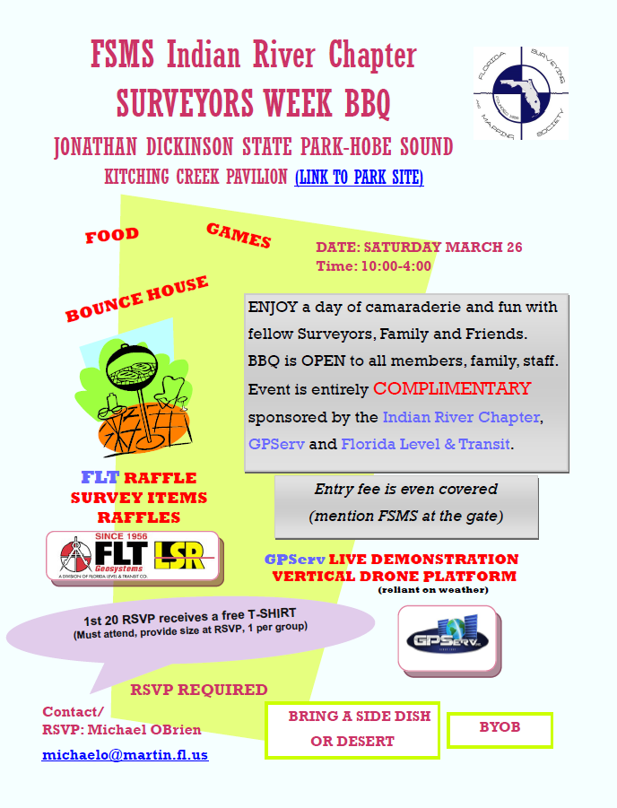
A pdf version of the announcement: FSMS-IRC-BBQ1…
Posted in News
Comments Off on FSMS Indian River Chapter Surveyors Week BBQ ( on March 26)
FAU Faculty visited Keith & Schnars Office in Ft. Lauderdale on Oct. 16
Drs. Kaisar, Teegavarapu, Nagarajan and Su visited Keith & Schnars Office in Ft. Lauderdale to meet with the administrative team and the technical team of K&S on Oct. 16. Both sides agreed to seek future collaborations on Geomatics, Transportation and …